

Sounder Hill
Ramanagara
Note on access
Inside a protected forest area. Trekking here without a permit and a guide is technically banned, so going on your own is at your own risk.
Why?
New rules announced in April 2026. We are working on documenting more offbeat trails outside protected forest areas.
Overview
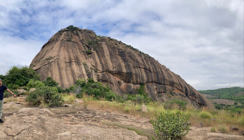
One of the best easy hikes around with great panoramic views from the top - easy to navigate, but currently restricted by forest officials, so plan accordingly.
Photos
Season
Any season. Stay clear of black wet patches on rock in the wet months.
🎟️ Permit
🚫 Entry prohibited by the Karnataka Forest Department. If you try to get a permit, you will most likely be refused.
Better to look for another hill to hike to during weekends.
Officially you're not allowed to hike up the hill, and there's a new sign near the temple parking prohibiting forest entry.
Nowadays, forest officials prevent hikers on weekends. I've completed multiple hikes without issues in the past (as recently as December 2024), but recent reports indicate increased enforcement.
This used to be a very good beginner-friendly hike not very far from Bangalore.
It is uncertain if the permit situation will change in the near future.
🐾 Wildlife
Not ideal to go here at night. In the daytime in a group of at least 2-3 people should be safe.
Elephants are known to occasionally visit the forest surrounding the hill. It is likely that sloth bears and leopards also roam the area, similar to most wild spaces in Ramanagara. The forest officials restrict entry to the area often due to increased elephant activity.
Trail description
You start walking from the temple along the mud road. In about 400 meters, you get off the road and turn right towards the hill. You walk about 100 meters through bamboo & brush to reach a rocky slope.
The ascent starts here. This rocky section might get a bit tricky during monsoons. So stay clear of wet patches.
First viewpoint
As you hike past the first rocky section and through the vegetation, you'll reach an opening. If you walk off the trail slightly to your left (southeast) you'll get a nice view of the valley below and the forest around.
Second viewpoint
As you follow the trail further through a green patch, you reach another opening. You get a 360-degree view from here.
To your right (west) is Ramanagara town. Ramadevara Betta too should be prominently visible on this side.
Behind you (northeast) in the distance is Bangalore city and its outskirts.
My favorite view is to the left (southeast) of the valley below and the expansive forest. The pond is also visible from here.
Hilltop
Continue on and in about 600 meters you'll reach the hilltop, marked by a flag.
You get to see several hills from in almost all directions from here.
You can spend some time here if it's windy. Usually it gets quite windy up here. But there's not much shade here to hide from the sun.
Cleanliness
You'll see a bit of trash littered around, but not too bad.
Crowd
Might get crowded on Sundays, since a lot of locals visit on Sundays. Any other day should be less crowded or completely empty. Saturdays mostly see little to no hikers.